A foggy winter morning, with mist obscuring the details in the distance. This is at a heritage site (most likely Machu Picchu), where a group of visitors are climbing up an ancient stone paved path, the years having caused damage to the path with the setting between the stones having become uneven, and in some cases, the stones themselves have come off and are no longer to be seen. This is high on the hillside, and cold and damp are a constant presence, leading to a large amount of moss everywhere. This site witnesses a huge number of visitors every year, and is very popular on the tourist circuit.
If you like this image and want a copy to hang on your walls, or want to check out some of my other creations,
please visit my Saatchiart page (link).
Want to improve your photos? Buy Photoshop and see how your images come to life.
Click to buy.
Want to get tips for improving your photography ?
Get Photo Tips from this blog.
 |
| Side section of the outside of the temple of Hatshepsut - Egypt |
A side section of the outside of the temple of Hatshepsut; the temple looks magnificent when you see it from the front. The temple is for one of the few female pharaoh (although everyone only thinks of Cleopatra when you mention female pharaoh).#Hatshepsut.
few female The temple is dedicated to the the God Amun and to the pharaoh. The temple is a grand construction, with three layered terraces, reaching a height of 29.5 meters tall. There were many sculptures of the pharaoh here, but many of them were destroyed by her successor and stepson Thutmose III after she died. Book: The Woman Who Would Be King: Hatshepsut's Rise to Power in Ancient Egypthttp://amzn.to/2aMPd7x The temple was magnificent; but we had gone in February and the temperature was very hot even then, so watch the temperature before you go if you cannot stand very hot weather.
Want to improve your photos? Buy Photoshop and see how your images come to life.
Click to buy.
Want to get tips for improving your photography ?
Get Photo Tips from this blog.
 |
| Cross in the Basilica of Bom Jesus in Goa |
Large weathered cross outside the Bom Jesus Basilica in Goa. This cross is located on a large base, and looks extremely weather beaten, what with the rainy weather. It is fairly large, and is one of the first structures you see when you enter the Gate of the Basilica compound from the parking side.#BomJesus. The Basilica is a UNESCO World Heritage Site, and very old, dating back to the 15th and 16th century, construction began in the year 1594 and was consecrated in the year 1605. It is very famous for having the body of the Saint Francis Xavier, the relic being preserved even after so many centuries. Every 10 years, there is a public viewing of the body, an event that draws a larger number of devotees.
Want to enjoy in Goa ? Lonely Planet India (Travel Guide) http://amzn.to/1I9Zirn — in Goa, India.
Want to improve your photos? Buy Photoshop and see how your images come to life.
Click to buy.
Want to get tips for improving your photography ?
Get Photo Tips from this blog.
 |
| Pigeons around the Jama Masjid in Delhi |
Pigeons flying around one of the minarets of the Jama Masjid in old Delhi. The Jama Masjid is one the magnificent struct6ures built by the Mughal Emperor Shah Jahan, taking a period of years and was completed in the year 1656 AD. Tourists can easily visit the place, except on Friday, when the prayers make it more difficult to visit. #JamaMasjidOriginal vintage postcard of Jama Masjid:http://amzn.to/1F3WHy7The mosque towers above the surroundings, being built on a 10m elevation (one has to climb steps fron the surroundings to get into the mosque). A visitor can climb one of the minarets and get some amazing views.
Want to improve your photos? Buy Photoshop and see how your images come to life.
Click to buy.
Want to get tips for improving your photography ?
Get Photo Tips from this blog.
The structure of Stirling Castle, as seen from a lower level (near the entrance, near the car parking). The Stirling Castle played a very significant role during the medieval centuries, when there was a fight ongoing for the Scots to retain their independence from the English, and there was also fighting going on between the different Scots for power. The Castle is surrounded by a high wall, and is itself located on a volcanic spur, much higher than the neighboring region, making it more
Get a Black and White print of this photo at
Fine Art America.
Get color print.
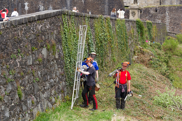
Historical monuments (especially those that are several centuries old) require a lot of maintenance. Just the sheer size of these monuments, and being exposed to different weather conditions, can cause a lot of damage and wear and tear. And with their heritage value, as well as having a large number of tourists visiting them on a regular basis, the need for maintenance is on a regular basis. In the photo, one can see maintenance workers on the wall of the Stirling Castle.
Get prints of this photo at Fine Art America (
Color,
B&W)
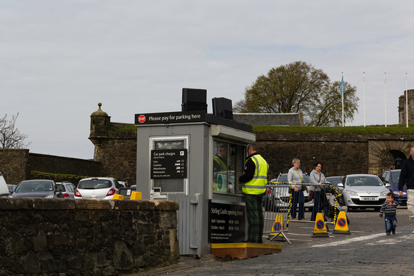
The parking lot near the entrance to the Stirling Castle. Even though the parking lot is as close to the entrance as possible, given the size of the structure, there will be some walking required, and any visitor will need to be aware of that. Having such a parking lot is extremely important because of the number of visitors to the Castle on a regular basis.
Get prints of the image at
Fine Art America.
Want to improve your photos? Buy Photoshop and see how your images come to life.
Click to buy.
Want to get tips for improving your photography ?
Get Photo Tips from this blog.
The Stirling Castle in Scotland, located near the town of Stirling, is one of the most important marks of the Scottish medieval ages history, the time when there were constant skirmishes between the Scots and the English (which ended when they got a common king in 1603, and then they were merged around a hundred years later). Close by, one a bridge over the Stirling river, one of the important battles of this fight for retaining their independence was fought, celebrated in the movie "Braveheart".
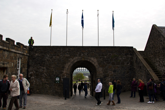
This is a photo near the entrance to the castle, and if you look through the entrance, you can see the gardens and even a hint of the river at lower levels (like most castles), the Stirling Castle is located at a higher level as a part of good defensive strategy. Over the entrance, you can see some flags, with the central flag being the Saltire, the Scottish Flag (as distinct from the Union Jack (the British Flag)). There are ongoing efforts to gain independence for Scotland, and the Saltire plays a key role in that.
If you want a print of this photo, available at
FAA.
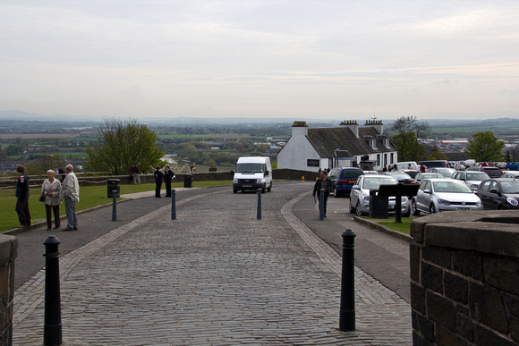
The Stirling Castle is located at a height over the surrounding, at a natural volcanic height called Castle Hill (the name sounds so appropriate, right?). The height and the natural beauty and greenery of the surroundings gives a beautiful look to the location, with houses and rolling meadows seen below. Vehicles are allowed upto the car parking which is located close to the entrance, but there will be some walking involved to the entrance, and of course, inside the castle, there will be more walking involved. The spot from where this photo was taken only allows vehicles belonging to the castle to go through, everybody else needs to park their vehicles in the car parking. From this location, there are also some view finders that allow you to see the landscape.
Prints of a version of this photo that has been converted into an Oil Painting
available at FAA.
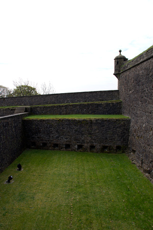
In addition to the huge advantage of being at a height from where you can see approaching enemies and try to pick them out as they climb up to reach the castle, there was the always the moat to deter attackers. This moat, now empty and looking beautifully green, would have been full of water and maybe some pollutants to deter people from trying to cross the moat other than through a narrow bridge (which could have been pulled up), all the while defenders from the top of the castle walls would have been attacking those who were attacking the castle. It looks so beautiful now, but is deep and would have been dangerous at those times.
Prints of a version of this photo that has been converted into an
Oil Painting available at 500px.
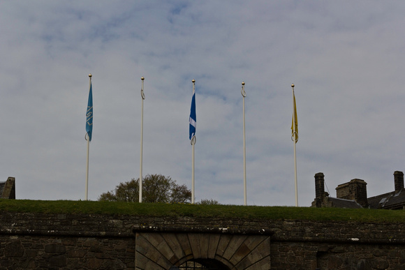
In the first photo above, visitors could be seen near and at the entrance to the Stirling Castle. This is a photo of the flags and flagpoles above the entrance. It was always interesting for me to see whether it would be the Union Jack (the official flag of Great Britain) or the Saltire (the Scottish Flag) at the various castles and other historical landmarks. In this case (and even at the Eilean Donan Castle), I could see the Saltire while the Union Jack was in a prominent position at Edinburgh Castle. I was hoping to get a photo with the flag fluttering, but there was no wind and hence no flutter.
Want to improve your photos? Buy Photoshop and see how your images come to life.
Click to buy.
Want to get tips for improving your photography ?
Get Photo Tips from this blog.
As in some previous photos, you get a view of the terrain on the way from Aswan to Abu Simbel. The terrain is a dry, almost desert kind of view, as you could see in this photo. The distance from Aswan to Abu Simbel is around 260km with most of this route being of a deserted and dry condition. One would not think that this would be true about being a dry place, given the presence of the massive River Nile through this area, but the Nile has been famous in the past as well for fostering greenery on a narrow patch next to the river, but otherwise the most common terrain type is that of a dry place.
The photo shows a large plain with a few hills in the distance, and no greenery in the place, just a vast flat area that seems like a desert. However, if you consider that the place is like a desert, the clouds that cover more than half of the sky seem to depict it to be other than a desert and a dry place.
Want to improve your photos? Buy Photoshop and see how your images come to life.
Click to buy.
Want to get tips for improving your photography ?
Get Photo Tips from this blog.
The journey from Aswan to Abu Simbel can take a fair amount of time, around 3 hours each way. Abu Simbel is a beautiful location, but it is some distance away from Aswan (taking a 3 hour journey on a highway with little traffic; or by flight - but that takes time since you need to check in to Aswan, do the procedures for security, and then disembark at the Abu Simbel airport and then make your way to the temple from the airport; or you can take a cruise from Aswan to Abu Simbel, but that can take even more time).
This was on the return journey from Abu Simbel to Aswan. Given the total journey time taken around 6 hours, and if you spend some time at the temple and have left in the morning from Aswan, then on the return journey, you will be close to sunset, and that is why we got these sights of the sunset over the horizon and the shimmer happens.
Want to improve your photos? Buy Photoshop and see how your images come to life.
Click to buy.
Want to get tips for improving your photography ?
Get Photo Tips from this blog.
Desert like road condition on the trip between Aswan and Abu Simbel. This part of Egypt, the southern half, is somewhat dry and barren. The River Nile does run through this region, but the river only provides a wet condition for a small stretch of land on either side of the river, but the rest of the place would remain barren.
When we traveled between Aswan and Abu Simbel, a view of the journey (a distance of about 3 hours, 260 km) showed land similar to what was in the photo. In the photo, it seems like a desert but not too much sand, more like a barren area with some scrub types of plants (at the minimum, you can see that there is not at all any kind of greenery in the place). Driving through such an area can be extremely boring, although you are able to maintain a high speed because of very little traffic and no distractions of any kind.
Want to improve your photos? Buy Photoshop and see how your images come to life.
Click to buy.
Want to get tips for improving your photography ?
Get Photo Tips from this blog.
A view of telecom transmission towers while we were on our way to the heritage location of Abu Simbel, located in south Egypt (moving from the larger town of Aswan). Abu Simbel is located at a distance of around 260 km from Aswan, and one can get there through the use of road, through ship over Lake Nasser, or through a plane. Most people take the road route, it being convenient and overall taking the least time. However, because of security concerns, visitors are not allowed to drive over there, and are expected to be taken there in convoys driven by tourist companies twice a day.
The route is fairly isolated, and most of the time, what we normally see along with the road are the electric lines that go alongside the route, and these telecom transmissions towers from time to time. Because of these towers, there is telecom connectivity even in this remote area.
Want to improve your photos? Buy Photoshop and see how your images come to life.
Click to buy.
Want to get tips for improving your photography ?
Get Photo Tips from this blog.
The area where the temple of Abu Simbel looks a bit barren. There is the River Nile flowing through the area, but as soon as you move a bit away from the river, you will come across mostly barren land and blue skies. So it was a bit surprising when I saw this cloud cover all over the area, and there is even a hint of dark cloud near the front of the photo, that could indicate a possibility of rain. However, in the couple of hours that we were there, we did not see any rain at the site and everything remained barren except for the greenery that was planted at the site. I spoke to a couple of people over there and they also claimed that there was very little rainfall at this site, even though there was a river flowing there and there was also the presence of Lake Nasser.
Want to improve your photos? Buy Photoshop and see how your images come to life.
Click to buy.
Want to get tips for improving your photography ?
Get Photo Tips from this blog.
A set of 3 palm trees located near the entrance to the Abu Simbel temple in south Egypt. The location of the Abu Simbel temple is so remote without anything nearby that after a journey of 3 hours on a deserted highway, when you actually get near the temple, everything seems good. These are trees near the parking lot and near the entrance to the temple, where you can see the upper levels of the stalls that have been set over there; and being able to see trees and greenery after this long road trip seems a great view.
There are 3 ways to get to Abu Simbel, through the road trip, or through a flight from Aswan, or through a river (lake) cruise from Aswan on a nice and comfortable cruise ship. The road trip works out the fastest, since there is none of the time related to boarding or getting off a flight, and it takes a bit less than 3 hours point to point (there is no stopping of the convoy in between).
Want to improve your photos? Buy Photoshop and see how your images come to life.
Click to buy.
Want to get tips for improving your photography ?
Get Photo Tips from this blog.
The large size of the hill housing the temple of Abu Simbel in south Egypt. There are actually twin hills, housing two temples (one honoring the pharaoh and the other honoring the chief consort of the pharaoh). These hills are all man made and are not the original location of the temple (as constructed by the pharaoh).
The original temple was made around 45 centuries back, and was located much lower down, closer to the river. However, after so many centuries, the creation of a dam was planned on the river Nile at Aswan, a dam which would be very massive and meant to provide a large amount of electricity as well as control the annual flooding of the Nile (which was useful in earlier times since that provided fertile soil, but was now very disruptive). The dam caused water levels to rise, and to save the temple from being flooded, the entire temple was cut into small blocks and moved to a much higher level (the current location).
Want to improve your photos? Buy Photoshop and see how your images come to life.
Click to buy.
Want to get tips for improving your photography ?
Get Photo Tips from this blog.
A number of visitors to Egypt who have come to see the wonders from Ancient Egypt also make it to see the temple of Abu Simbel. Even though the temple is not as famous as the Pyramids or the Sphinx, the temple is still relatively famous. Getting there is not as simple as visiting the pyramids though (which are located on the outskirts of Cairo). The Temple of Abu Simbel is located in an isolated area, 260 km by road from the nearest big town of Aswan (you can also get there by flight or by ship across Lake Nasser).
It is Lake Nasser which made it famous. Lake Nasser is a man made lake which was created due to the construction of the dam at Aswan, and as a result, the rise in water levels threatened the temple; in an engineering feat, the temple was moved up from the lower level and moved to the current location. The hill housing the temple was created to house the temple, and in this photo, you can see the backside of the hill with a entrance meant for service purposes.
Want to improve your photos? Buy Photoshop and see how your images come to life.
Click to buy.
Want to get tips for improving your photography ?
Get Photo Tips from this blog.
The temple of Abu Simbel is an incredible monument, a heritage. It was constructed by the great Egyptian pharaoh Ramesses II around 45 centuries back and was constructed in the form of a twin temple - one temple dedicated to the honor of the pharaoh, and the other to the chief consort of the pharaoh (which was incredible by itself, since the wife of the pharaoh was never given such an honor before).
The other significant detail about the temple is that it was moved from its original position in the 1960's. The construction of the Dam at Aswan was creating a large reservoir, and the rising water of the reservoir threatened the temple, and hence the engineering effort was needed to cut the temple into blocks that were then re-assembled at a higher level with a high degree or accuracy.
Want to improve your photos? Buy Photoshop and see how your images come to life.
Click to buy.
Want to get tips for improving your photography ?
Get Photo Tips from this blog.
A view of the four large statues at the entrance to the temple at Abu Simbel. There are actually twin temples, out of which you are seeing one. The primary one is dedicated to the great pharaoh Ramesses II (who built the temple approx 45 centuries back), with another one being dedicated to his chief consort (and it was very astonishing that a temple was being dedicated to his wife, since such a thing was not heard of before).
The temple has these 4 huge statues at the entrance, and you can get an idea of the size of these statues from the entrance located in the lower middle, which is much below the overall height of the statues. These are truly remarkable structures, made more so from the fact that these were not the original location of the temple, it being moved up from a lower level to escape the rising waters of the river Nile due to dam being constructed at Aswan.
Want to improve your photos? Buy Photoshop and see how your images come to life.
Click to buy.
Want to get tips for improving your photography ?
Get Photo Tips from this blog.
The temple at Abu Simbel in the southern part of Egypt is actually a twin temple, with a temple dedicated to the pharaoh and the smaller one to his wife. This is the entrance to the larger temple, which has 4 huge statues at the entrance. In this photo, you can see 2 of the huge statues along with the upper portion of the entrance to the temple (located in the lower left portion of the photo).
The temple at Abu Simbel is very famous for being one of the works undertaken by the great pharaoh Ramesses II, on the river Nile, apparently in the middle of nowhere. The temple was located at a lower level where it was under threat of being submerged by the rising water caused due to the construction of the High Dam at Aswan, and in an engineering feat in the 1960's, was moved to a higher level (the current position of the temple).
Want to improve your photos? Buy Photoshop and see how your images come to life.
Click to buy.
Want to get tips for improving your photography ?
Get Photo Tips from this blog.
The temple of Abu Simbel is located in the southern portion of Egypt, not far from the border with Sudan. The temple was constructed by the great pharaoh Ramesses II and was meant as a display of his grandeur and also as a reminder of the power of Egypt to the visitors from the south who would be traveling on the river Nile (and the temple was located on the banks of the river).
The temple is actually twin temples, both of them with large statues in front. This is the view of the larger one, the one dedicated to the pharaoh. These are huge statues, towering over the visitors who cannot be seen in this photo (you can get an idea of the size when you look at the entrance in the middle of the photo, and the statues towering over the entrance to the monument). Over a period of time, one of the statues has been lost above the waist, but if you consider that the temple and statues have been existing for around 45 centuries, you cannot help but feeling impressed.
Want to improve your photos? Buy Photoshop and see how your images come to life.
Click to buy.
Want to get tips for improving your photography ?
Get Photo Tips from this blog.
When visitors go to see the tourist attraction of Abu Simbel located in the southern portion of Egypt, most of them do not even realize that what they are seeing is not strictly the original. The statues and contents of the sanctum are original, but the location and the hillock housing the temple are not original, but were actually created only in the 1960's.
Due to the construction of the high dam at Aswan with the consequent creation of the reservoir called Lake Nasser, the rising water threatened the original location of the Abu Simbel temple. There was a huge engineering effort to create a small dam around the temple to prevent water from entry, and then the entire temple was cut into small blocks and then taken to a higher location and re-created in exactly the same manner (the difference being that the original temple was on the side face of the rock, while the new temple is located in a hillock).
tourist attraction posters
Want to improve your photos? Buy Photoshop and see how your images come to life.
Click to buy.
Want to get tips for improving your photography ?
Get Photo Tips from this blog.
The current structure of the temple at Abu Simbel is a mix of old and new. The temple was originally built during the time of the Great Pharaoh Ramesses II, and served as a reminder to the people in the area and visitors from Nubia making their way on the Nile to Egypt about the greatness of the pharaoh for having constructed such a huge structure. However, the plans for the construction of the High Dam at Aswan envisaged the creation of a huge fresh water reservoir which would contain the dammed up water of the River Nile, leading to the creation of Lake Nasser. The high waters of the lake were going to submerge the temple, and hence it was moved to a higher level but with exactly the same configuration (including the light effect where twice a year light from the sun would reach inside the inner sanctum of the temple and light up some of the gods but not the god of the underworld).
skyline acrylic prints
Want to improve your photos? Buy Photoshop and see how your images come to life.
Click to buy.
Want to get tips for improving your photography ?
Get Photo Tips from this blog.




 RSS
RSS


